
Canada is battling more than 1,000 active fires, and nearly two-thirds of them are out of control.
Canada is experiencing its worst wildfire season on record with tens of thousands of people being driven out of their homes as flames spread, forcing the federal government to deploy the military.
Nearly 200 homes and structures have been lost or damaged by the wildfires burning in Kelowna, British Columbia. Cooler conditions have brought some relief to the region even though smoke continues to blanket the province.
While Canada experiences fires every summer, this year’s blazes have scorched at least 15.3 million hectares (37.8 million acres) of land, nearly 10 times more than 2022 and roughly the size of New York state.
According to the Canadian Interagency Forest Fire Centre (CIFFC), 1,036 active fires are burning throughout Canada with 652 categorised as “out of control, “161 “being held” and 223 considered to be under control.
Where are the wildfires burning?
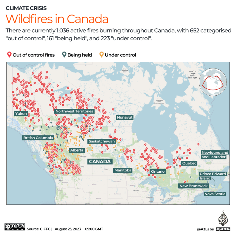
About two-thirds of all active fires are burning in the western provinces of British Columbia (376) and the Northwest Territories (237). An additional 143 fires are burning in the Yukon, 88 in Alberta and 66 in Ontario.
According to the CIFFC, 5,881 fires have been recorded across the country this year so far, about 1,000 more than last year.
How much area has burned?
The land that has burned this year so far is more than double the size of the United Arab Emirates and triple the size of Costa Rica.
To put the 15.3 million-hectare figure into perspective, an area of 1 million hectares is the same as 10,000 square kilometres. That means the fires have burned 153,000sq km, or 59,000 square miles.
This year’s fires have now burned more than double the area of the previous record of 7.1 million hectares torched in 1995.

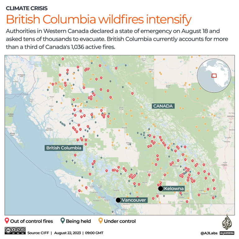
British Columbia wildfires intensify
British Columbia declared a state of emergency on August 18 as a fire in the southern part of the province grew more than a hundredfold in 24 hours. More than 35,000 people have been asked to evacuate their homes.
The fire is centred around Kelowna, a city of 150,000 people located about 300km (180 miles) east of Vancouver. Sections of some key transit routes between the Pacific coast and the rest of western Canada have been partially shut down.
Nearly 1,900 fires have scorched 1.7 million hectares (4.2 million acres) of land in British Columbia this year so far. This has led to hazardous levels of air quality across many parts of the province.
Fires across the Northwest Territories
Another devastating blaze is threatening Yellowknife, capital of the Northwest Territories.
On August 15, authorities issued a state of emergency there as more than 200 wildfires burned across the territory in northern Canada. All 20,000 of Yellowknife’s residents were asked to evacuate by air or land as firefighters battled the flames.
About 270 fires have burned more than 3.4 million hectares (8.4 million acres) across the Northwest Territories, according to the CIFFC.

#Mapping #scale #Canadas #record #wildfires #Climate #Crisis #News


